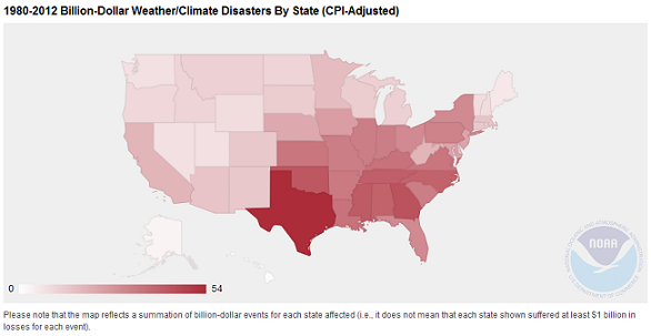
Weather and climate have a tremendous impact on the southern U.S. The NOAA National Climatic Data Center (NCDC) Billion-Dollar Weather/Climate Disaster map (Figure 1) reminds us that SCIPP states are among the most hazard-prone in the country. Planning and preparing for these hazards is an important job function for many of SCIPP’s stakeholders.
SCIPP initially surveyed stakeholders who are involved in hazard planning and preparing for weather and climate hazards and/or work in a land, water, or wildlife management capacity in 2009. The survey sought information related to three areas: 1. Local Level Hazard Planning, 2. Climate Change and Hazard Planning, and 3. Information Use and Needs for Effective Hazard Planning. The results of the survey provided us with a baseline understanding of the climate-related hazards that are most important to stakeholders in the region as well as the information that is needed to help them make informed decisions.
We recently surveyed stakeholders in the region for a 2nd time to determine whether concerns and needs have changed over the last four years. The data have been collected and are being analyzed. The results of the study will be available this summer. An accurate understanding of the climate-related concerns and needs in the region ensure that our research activities are aligned with the priorities of those involved in hazard planning across SCIPP states. We are grateful for those who took the time to participate.