Earthquake
Data Limitations
Globally, scientific understanding of earthquake processes is somewhat limited, and the available history of seismicity is typically too short to establish reliable spatiotemporal patterns of large earthquake occurrences (Stein et al. 2012).
Definition and Description
A sudden slip on a fault, with resulting ground shaking and radiated seismic energy caused by the slip, or by volcanic or magmatic activity, or other sudden stress changes in the earth (USGS 2018).
Earthquakes occur from the sudden release of stress in the Earth’s crust. Stress is built up by the motion of tectonic plates. Stress may also be built up through the injection of fluids. During an earthquake, rocks on either side of a fault line move either horizontally or vertically. This movement creates three types of waves: Primary, Secondary and Rayleigh waves. Primary waves spread outward from the epicenter (source of the fracture) as compression, like a spring. Secondary waves vibrate at right angles to the direction of travel; these are the most damaging. Rayleigh, or surface, waves move vertically, giving an undulating motion. While strong earthquakes are not common in Arkansas, the state is positioned over the New Madrid fault line. An earthquake caused by the New Madrid fault, situated in the Mississippi Valley, would greatly impact Arkansas.
Earthquake intensity is measured on the Moment Magnitude Scale. Each point represents a 10-fold increase in the wave amplitude and a 32-times increase in energy release.
Historical Data
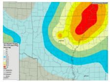
Arkansas Seismic Hazard Map
(2014) U.S. Geological SurveyThis static map shows the probabilistic peak earthquake ground acceleration with a two percent probability of exceedance in 50 years. This map consists of the most current assessment of earthquake acceleration probabilities and can be used when assessing potential seismic provisions.
1. Using the legend on the left, identify area of interest and associated probability risks.
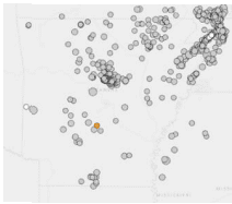
Earthquake Catalog
(Period of record varies by location; up to ~70 years) U.S. Geological SurveyShows past earthquakes on a zoomable map and can be used to show previous occurrences.
1. Under Basic Options, select the Magnitude, the Date and Time, and the Geographic Region to plot. You can select a Custom Geographic Region and draw a rectangle over Arkansas by using the + button to zoom to the state. 2. Click Search. 3. A map with all earthquakes meeting your chosen criteria are shown and a list of earthquakes are on the left of the page. 4. View the map legend by clicking the key icon on the top right of the map area. To learn more about specific events, click any point on the map or select an event from the list. You can also sort by date or magnitude.
Arkansas Earthquake Information Page
U.S. Geological SurveyAdditional information about earthquakes in Arkansas. Click on links of interest.
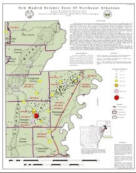
New Madrid Seismic Zone of NE Arkansas
(Last Update: 2008) Arkansas Geological SurveyThis page leads to a map showing locations and magnitudes of earthquakes in the New Madrid seismic zone of Northeast Arkansas.
1. Scroll to the bottom of the page and click Download PDF to access the map. 2. Legend and associated information are found on the PDF.
Climate Change Trends
Between 1811-2013, Arkansas experienced on average 1-2 earthquakes per year that were magnitude 3.0 or greater. Additionally, the state often experiences smaller magnitude earthquakes per year, although they are often not felt. The state lies within the New Madrid seismic zone (NMSZ), an active earthquake zone
that has produced some of the largest earthquakes within the continental borders. The NMSZ has experienced recent seismic events as late as 2005 and is still considered active and is potentially capable of generating powerful earthquakes (AGS 2015). Note: this section of the Simple Planning Tool is titled ‘Climate Change Trends’, but in the case of earthquakes please regard this as future trends.