Coastal Erosion
Data Limitations
Coastal erosion is complex because of the many factors that affect the changing coastline, including sea level rise, coastal flooding, subsidence, winds, and wave action. Therefore, measuring changes from erosion can be difficult. Coastal gauges are also sparse, so there is limited historical data at many locations. Satellites have greatly improved observations of eroding coasts but do not yet provide a long-term record. Long-term changes are found through a combination of archived aerial images, surveys, coastal gauge data, and satellite observations.
Definition and Description
The process by which local sea level rise, strong wave action, and coastal flooding wear down or carry away rocks, soils, and/or sands along the coast (U.S. Fed. Gov., 2021).
Coastal erosion naturally occurs through storms, strong waves, and high tides, and sea level rise exacerbates this issue (U.S. Fed. Gov., 2021a). Coastal change, including from erosion and sea level rise, is measured by remote sensing (e.g., aerial photography, satellite imagery, photogrammetry, and lidar), surveys, and coastal gauge data.
Coastal erosion causes coastal property loss (infrastructure and land/beaches), reduction of wetlands/marshes, and negative impacts to the economy (e.g., transportation infrastructure, business and tourism disruption, decreased property values). The loss of wetlands causes further impacts from tropical storms because wetlands act as a buffer to storm surge and tropical storm winds. In Texas, wave action from the Gulf Intercoastal Waterway and shipping canals is one cause of eroding coastal marshes (TPWD 2024).
The Texas General Land Office (2024) stated, “Sixty-four percent of the Texas coast is eroding at an average rate of about 6 feet per year, with some locations losing more than 30 feet per year.”
Historical Data
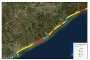
Coastal Change Hazards Portal
(Historical: ~150 years; short-term change: ~30 years, long-term change: ~78+ years) U.S. Geological SurveyAccess this tool to view historical shorelines and short- and long-term shoreline change rates due to hurricanes, coastal erosion, and sea level rise.
1. To view coastal erosion changes, zoom into the area of interest 2. Select Shoreline Change from the righthand menu. 3. Choose to view long-term or short-term shoreline change rates or historical shoreline positions. 4. Click Gulf of Mexico shorelines, then choose Texas. The map will show your selection along the Texas coast.
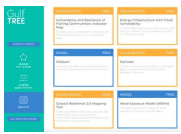
Gulf Tree
(Period of record varies by product)Northern Gulf of Mexico Sentinel Site Cooperative, Gulf of Mexico Climate Resilience Community of Practice, & Gulf of Mexico Alliance Resilience TeamThis decision support site guides users to the coastal erosion tools and resources they need along the Gulf Coast through several filters of information, including how much time and effort they’re willing to spend on the tool.
1. Choose a Filtered Search to look through all filter categories on one page or choose Guide My Search to walk through questions step by step to achieve what you’re looking for. 2a. If you chose the Filtered Search, first navigate to Geographic Scope. Click the Texas drop-down menu and choose Shoreline to select all coastal counties or choose specific one(s). 2b. Under Tool Function, select what you’d like to use coastal erosion information for. 2c. Under Cost, choose Free. 2d. Under Level of Effort, choose from low, moderate, or high (will determine how advanced the tool is). 2e. Under Climate Change Themes, check the box for Sea Level Rise. 2f. Under Climate Change Topics, select the drop-down for Coastal Processes, then check the box for Erosion. 2g. Click View Tool Matches on the top right to go to the results page. Click any of the tools or resources to go to that site.
3a. If you chose Guide My Search, Gulf Tree will walk you through the same filters by asking 6 questions. For step 1 (Tool Function), check the box for why you need a coastal erosion tool, then click Submit. If you’re not sure which option to use, you can Skip this step. 3b. Step 2 (Topic Area) includes a filter for what aspect of the topic you’re interested in. Click the drop-down menu for Coastal Processes and check the box for Erosion, then click Submit. 3c. On Step 3 (Location), click the Texas drop-down menu, then choose Shoreline to select all coastal counties or choose specific one(s). Then, click Submit. 3d. For Step 4 (Level of Effort), choose how much effort you’d like to put into the tool, which will determine how advanced the tool is. Then, click Submit. 3e. For Step 5 (Tool Cost), choose Free, then click Submit. 3f. Click Leave Guided Search and View Matches to go to the results page or go back to a previous page on the left menu to change your selected options. Click any of the tools or resources to go to that site. 4. To create a new search, click Reset All Filters at the top right of the results page.
Climate Change Trends
Sea level rise increases coastal erosion, so we can expect erosion to increase over time (USGCRP 2019). On the Texas coast, beach erosion is 10 feet per year, on average (Kloesel et al. 2018). According to the USGS Coastal Change Hazards Portal data, some areas of the Texas coast have eroded more than 15 feet per year over the last ~30 years. The erosion of 56% of freshwater wetlands is expected in the middle coast of Texas by 2100, removing protective coastal barriers (Pathak and Fuller 2021). Read more about future coastal erosion in Climate Change Science and Projection Resources.