Barry Keim, Southern Climate Impacts Planning Programs, Louisiana State University
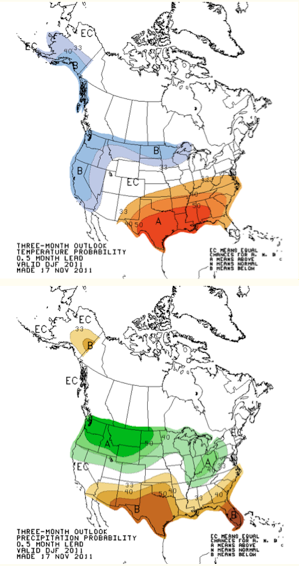
Our winter forecast for most of the SCIPP region calls for warmer and drier than normal conditions, with the exception of Tennessee, where the forecast calls for wetter than normal conditions (Figure 1). Actually, what the Climate Prediction Center is really noting is that the probability of having a warmer and drier than normal season is enhanced, thereby having a higher than average chance for these conditions. This forecast is entirely consistent with what we would expect during a La Nina winter. In this instance, the jet stream and storm tracking tends to shift northward bringing rains to the Ohio River Valley, including Tennessee, and leaving the southern United States warm, and high and dry.
If you consider how poorly forecasters are at predicting weather 4 or 5 days in advance, you would think that forecasting months ahead would be nearly impossible. Well, predicting specific weather events weeks to months in advance is impossible, indeed. Predicting climate, on the other hand, is a little different, although nonetheless daunting. There have been some recent breakthroughs in this science and it can be done with some (limited) success. Climate forecasters are becoming better skilled as result of understanding teleconnections. A teleconnection is an association of weather that takes place in differing parts of the earth. In this case, the reference is to our current La Niña. La Niña is a phenomenon that takes place in the eastern tropical Pacific Ocean, yet it has impacts on weather and climate in certain parts of the world, including the south-central United States. During past La Niña events, the south-central United States has tended to be warmer and drier than normal. Not surprisingly, this is precisely the forecast by NOAA’s Climate Prediction Center for the region for this upcoming winter season. Clearly, this is not good news for those being impacted by the current drought conditions.